If you travel east around the world, you do not just cover more miles. You also gain time, because the next local clocks have already moved ahead. If you travel west, clocks fall behind. This happens even though Earth keeps its steady 24-hour spin.
World time zones exist to keep daily life aligned across long distances. They also reduce mistakes in travel, meetings, shipping, and power grids. Therefore, time zone divisions are not random lines on a map. They are a structured system, mainly based on longitude time zones.
This guide explains how the world gets divided, why the borders bend, and where the system breaks with common exceptions. It also covers real-world quirks you will notice in the Americas, Europe, and the Pacific. Next, you will see the science that turns Earth’s rotation into standard clock offsets.
Why Longitude Rules Time: The Science Behind the Zones
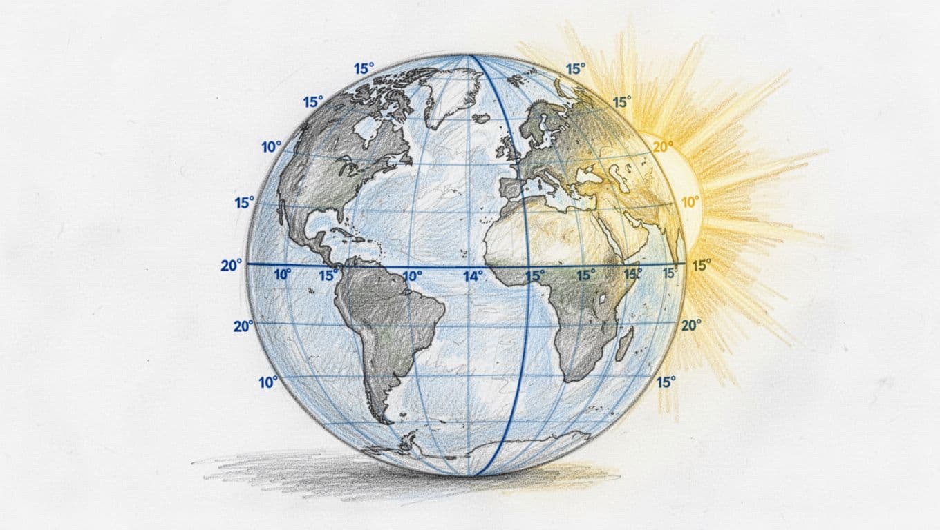
Time zone design starts from a simple rule: Earth rotates 360 degrees in about 24 hours. That ratio is fixed for planning purposes. When you divide 360 by 24, you get 15 degrees per hour. As a result, longitude time zones often follow strips that are about 15 degrees wide.
In practical terms, the Sun reaches the local “high point” at slightly different times across longitudes. For example, if one location lies 15 degrees east of another, the first location sees solar noon about one hour earlier. Then local clocks follow that pattern by using standardized offsets from a common reference.
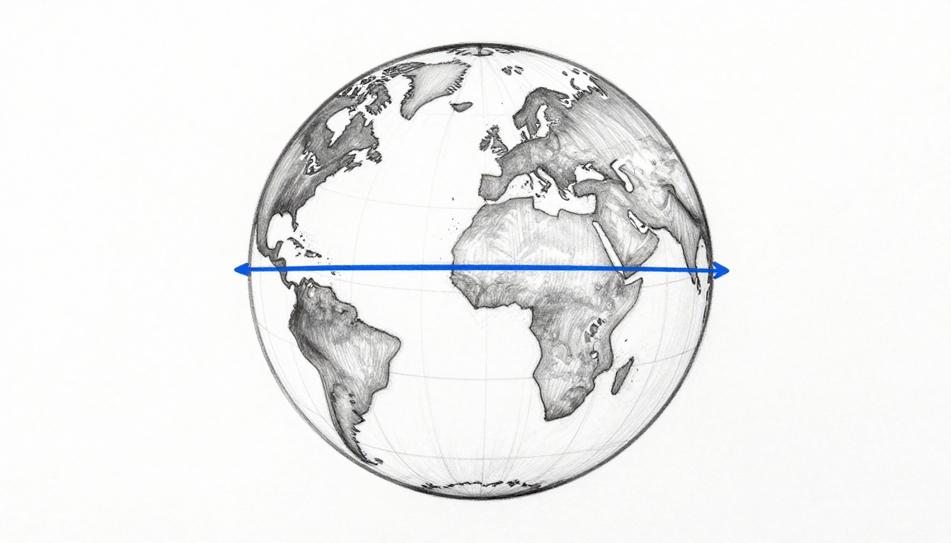
A key point governs most maps: the system uses UTC (Coordinated Universal Time). UTC acts like a baseline for time zone calculations. The “center” idea matters too. When a zone is centered on a meridian, solar noon usually lines up near noon local clock time.
For a visual reference on how the Prime Meridian connects to day and night, see the Prime Meridian and time zones explainer.
Finally, borders do not track pure longitude because countries need workable schedules. Borders bend for political boundaries, transport links, and social convenience. So, the “15-degree logic” sets the framework, while real governments shape the final boundaries.
How Earth’s Rotation Creates Time Differences
Earth spins in a direction that makes the Sun appear to move across the sky. If you stand on the ground, sunrise arrives earlier in the east than in the west. This ordering matches the east-west spread of daylight.
Because the rotation rate is about 15 degrees per hour, the Sun’s apparent progress produces a clock offset at each 15-degree step. Therefore, moving 15 degrees east typically adds about one hour. Moving 15 degrees west typically subtracts about one hour.
A simple analogy works for planning: imagine you stand on a merry-go-round that turns at a constant speed. One person steps forward at the top of the ride. Another person steps forward a little later, because the timing of arrival depends on where each person started. The clocks behave the same way, except the “timing” comes from longitude and the Sun’s position.
In policy terms, this means local time is not one global number. Instead, local time depends on agreed offsets from UTC. The offsets aim to match the Sun’s daily cycle in each region, with acceptable error for daily schedules.
Still, time differences are not only about daylight. They also matter for law, commerce, and public services. As a result, time zone divisions become part of how countries manage timekeeping at scale.
Standard Meridians: The Heart of Each Time Zone
The standard method assigns each zone an offset from UTC, usually written as UTC plus or minus hours. The “plus” means the local time runs ahead of UTC. The “minus” means it runs behind.
The Prime Meridian sets the baseline. At UTC+0, the center meridian runs through Greenwich at 0 degrees longitude. From there, each step east is typically about 15 degrees and each step west is typically about 15 degrees.
Several reference points illustrate the range:
- UTC+1 roughly aligns with about 15 degrees east, a common reference band for parts of Western Europe.
- UTC+9 aligns near 135 degrees east, which matches Japan’s typical timekeeping.
- UTC-12 to UTC+14 covers the full set of practical hour offsets used worldwide.
It is also correct to state an operational limitation. Time zones do not map perfectly onto the real Sun at the exact zone edges. Still, the system supports scheduling because the offsets stay consistent within each zone.
Also, “standard meridian” does not mean every place follows the center line. Instead, it means the offset is chosen to represent the zone’s general geography. Borders then shift away from strict meridians so countries can operate under one or two times instead of many.
A Brief History: From Railroad Chaos to Global Standard
Before time zones, many places used local solar time. Under local solar time, noon meant when the Sun reached its highest point. That method worked for small areas. It failed under fast travel and long-distance coordination.
Railroads introduced a timing problem. Schedules needed consistent clock readings over large distances. Otherwise, train times contradicted each other across stations. In response, standard time became a practical requirement, not a theory.
Sir Sandford Fleming proposed a global scheme in the late 19th century. His proposal focused on dividing the world into standard zones so travel could run on predictable rules. Later, the international community selected a Prime Meridian reference at Greenwich.
In 1884, the International Meridian Conference chose Greenwich as the basis for the Prime Meridian. After that, the world moved closer to a shared time framework. Then, clocks could be set using agreed offsets rather than local Sun observations.
From this point, the system evolved into modern time standards. The GMT idea gave way to more precise timekeeping, and UTC became the core reference. UTC stays stable year-round for baseline calculations, even when some countries apply daylight saving time changes.
For a readable history focused on Fleming’s role, see how Sandford Fleming changed timekeeping.
Finally, it matters that the structure remains largely stable. As of March 2026, no major worldwide time zone division changes were reported. Instead, day-to-day differences come from DST schedules, border policies, and a small set of special offsets.
Mapping the 24 Main Time Zones and Big Country Splits
The most common public explanation says the world has 24 main time zones. In operational terms, this covers offsets from UTC-12 through UTC+14. The usual map logic ties each hour offset to roughly 15 degrees of longitude.
However, you should treat “24 zones” as a planning simplification. Borders shift. Offsets shift for national decisions. Meanwhile, some countries use half-hour or quarter-hour offsets, which complicates strict “hour strips.”
To keep the idea concrete, consider the United States mainland. It uses four main offsets:
| US region (mainland) | Typical clock label | UTC offset |
|---|---|---|
| Pacific | PT (or PDT in summer) | UTC-8 (UTC-7 in DST) |
| Mountain | MT (or MDT in summer) | UTC-7 (UTC-6 in DST) |
| Central | CT (or CDT in summer) | UTC-6 (UTC-5 in DST) |
| Eastern | ET (or EDT in summer) | UTC-5 (UTC-4 in DST) |
A second example shows how large countries can still use fewer zones than geography suggests. China keeps a single national time (UTC+8) even though its west-to-east span would support many strips. As a result, sunrise and noon timing differ across provinces, but the clock reading remains one standard.
If you want an interactive way to confirm offsets and observe boundary behavior, use this interactive world time zones map. The tool helps because time zone divisions rarely form neat rectangles.
Australia and Russia show another split in practice. Australia varies by state, and many regions use daylight saving time. Russia has used a stable arrangement without DST since 2014, which means its offsets stay steady through the year.
For global context on the typical 15-degree rule and how maps explain it, see how a world time zone map works.
Which Countries Span the Most Time Zones?
A useful question for planners is simple: which countries force the most internal time zone changes? In most cases, the answer tracks size and distance more than politics alone.
Russia often appears at the top of lists for the number of time zones it covers. The United States also spans multiple time zones across its mainland. France operates multiple zones globally due to territories.
The following pattern generally applies:
- Russia uses many zones across its wide east-west reach.
- The United States uses four main zones on the mainland, with additional offsets for territories.
- Canada uses multiple zones due to its geography.
- Australia uses multiple time zones, mainly because states apply different rules.
For a practical confirmation of country counts, you can cross-check with a compiled country ranking source like countries with the most time zones. While you should not treat any single source as final policy, these lists help you understand why maps show so many internal divisions.
The compliance takeaway is operational. A large country can adopt one national time, or it can split internally. Either way, the goal stays the same: reduce confusion inside the country’s public systems and commercial schedules.
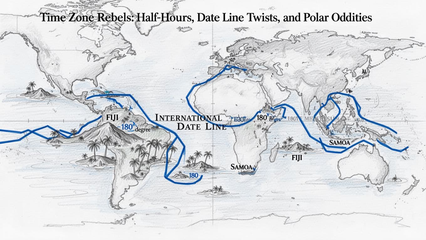
Time Zone Rebels: Half-Hours, Date Line Twists, and Polar Oddities
Most of the time, time zone divisions follow hour offsets from UTC. Still, several “rebels” exist, and they matter because they break assumptions.
Some countries use half-hour offsets. Others use 45-minute offsets. The offsets exist because local leaders built timekeeping around solar timing and practical compromise. In addition, they sometimes align with neighboring trade partners and regional schedules.
The second rebel is the International Date Line. It does not act like a perfectly straight line at 180 degrees longitude. Instead, it zigzags to keep island groups together under one calendar day.
The third rebel appears at the poles. At the poles, longitude lines converge, but daylight patterns become extreme. As a result, standard “local Sun time” becomes less useful, so stations rely on selected reference times.
The final rebel is daylight saving time. DST does not change which zones exist. But it changes the offset during part of the year, which means the gaps between zones shift temporarily.
Half-Hour and Quarter-Hour Offsets That Defy the Hour Rule
The hour rule says 15 degrees equals one hour. The clock system does not guarantee that every place picks whole hours. In fact, some places use offsets like UTC+5:30 or UTC+4:30.
A common set includes:
- India at UTC+5:30
- Nepal at UTC+5:45
- Afghanistan at UTC+4:30
- parts of Australia with offsets that do not align to full hours
To verify how widespread half-hour and 45-minute time zones are, see half-hour and 45-minute time zones. That reference provides an overview of where the non-hour offsets appear and why the offsets exist as recognized choices.
In simple compliance terms, you cannot assume “one hour per zone step” when you do international scheduling. You must read the exact UTC offset for the location.
Crossing the International Date Line: Day Jumps Explained
The International Date Line exists to keep calendars consistent with local decisions. It runs close to 180 degrees longitude in the Pacific, but it bends around land and island groups.
When you cross the Date Line from west to east, local time moves forward by a day. When you cross from east to west, local time moves back by a day. So, travelers see an apparent day jump.
A concrete example highlights the effect. The Diomede Islands split between Russia and the United States area. They sit close together in distance, yet they can be a full day apart because of Date Line placement. The result is measurable and repeatable, not an error.
Also, Samoa changed its time zone position relative to the Date Line in 2011. That change aimed to align with trading partners and improve calendar unity. Once a country makes that kind of adjustment, it becomes part of the national timekeeping record.
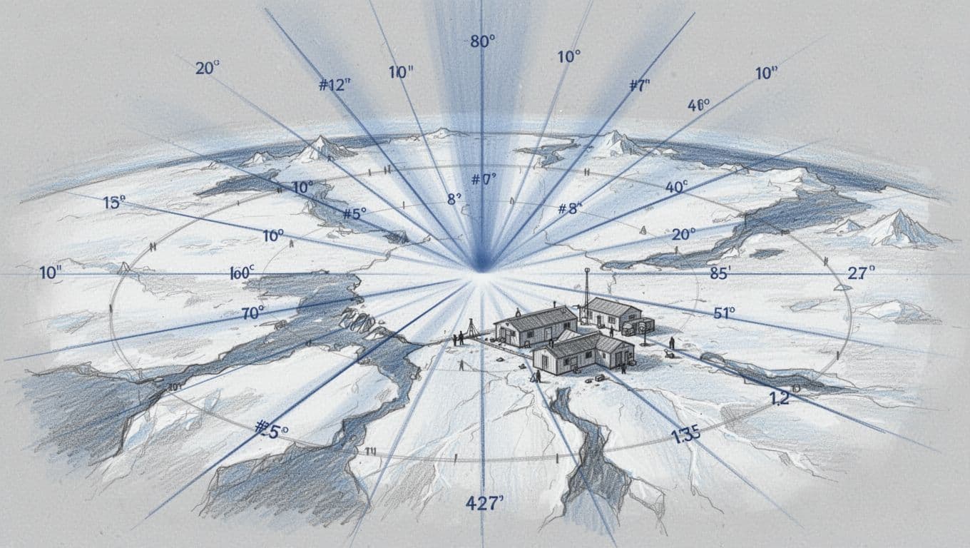
What Time Is It at the Poles? Arctic and Antarctic Time Tricks
At the poles, time zone logic becomes less intuitive. Longitude lines meet at the same point, but day length does not follow “normal” cycles. Instead, the Sun can remain above the horizon for long periods.
Because of those conditions, Arctic and Antarctic research stations typically use a reference time. Common choices include UTC or the home country’s time. The station does not need a changing offset every hour to track sunlight. The operational needs are different, so the time selection supports work coordination.
In the field, polar timekeeping usually follows practical policy. Staff may schedule meals, radio windows, and shifts based on one chosen standard. Therefore, the polar location can be “inside” several theoretical longitude zones, but in practice it uses a stable reference.
Daylight Saving Time: When Clocks Spring Forward and Fall Back
DST changes clocks by one hour during a seasonal period. DST does not rewrite longitude time zones. However, DST changes the offset you apply when you calculate differences.
As of late March 2026, the baseline DST status reported for major regions includes these operational points:
- United States: most areas use DST. The shift started March 8. That means Pacific is PDT (UTC-7), Mountain is MDT (UTC-6), Central is CDT (UTC-5), and Eastern is EDT (UTC-4).
- Europe: many places use DST. The UK uses BST (UTC+1), and parts of Eastern Europe use CEST or EEST depending on local rules.
- Russia: no DST since 2014. Moscow stays UTC+3 year-round.
- China: no DST ever. China stays UTC+8 year-round.
- Australia: varies by state. Some areas use DST, including Sydney at AEDT (UTC+11) during its DST period.
If you need a global listing for DST observance in 2026, refer to Daylight Saving Time around the world 2026. That reference helps you avoid scheduling errors around clock-change weeks.
A practical risk note follows. When DST starts or ends, the time gap between two places can change overnight. Therefore, meeting times need re-checking during those weeks, especially when your schedule crosses multiple regions.
Conclusion
World time zones divide Earth into organized clock regions mainly by longitude. The system uses UTC as a standard baseline, and it typically assigns zones in hour steps tied to Earth’s 15-degree-per-hour rotation rate. History then refined the approach, especially after railroads required consistent scheduling.
In addition, time zone divisions are not pure math. Borders bend, some countries use half-hour or 45-minute offsets, and the International Date Line creates day jumps. DST changes add another layer of variation, so offsets can shift seasonally in some areas.
If you remember the one governing idea, it should be this: time zones exist to keep real life synchronized across Earth’s rotation. So, before you plan travel or schedule a call, verify the exact UTC offset for the location and date. After that, you can treat the map as a tool, not a mystery.